
THE CENTRE OF BRITAIN

The CENTRE OF BRITAIN Concept
"Symbols of the Centre are among the most persistent of myth and belief, appealing to the curious minded or to the curious part of everyone's mind.They are monuments to our instinctive everlasting perception that every being needs to affirm its own its own identity by finding its own Centre"
John Michell - Author on symbolism from his book "At the Centre of the World"

The Ancient civilisations - Egyptians, Greeks, Vikings, Romans often situated the centres of their territories by calculating their mid point of the longest North - South axis, especially if other mid points coincided.
Natural features such as a commanding position on high ground or the confluence of rivers or trade routes were also taken into account.
Applied to Britain, the longest North - South median is from the North of the Orkney Islands to Portland Bill in Dorset - 2° 26' W
Hoe Sherries, North Rowlands Way 59° 23' 18" N
Fresh Water Bay, Portland Bill 50° 31' 48" N
Mid Point - Haltwhistle 54° 57' 33" N
From which point there are equidistances to all main main compass points, as well as to the Centres of England, Wales, Northern Ireland and Scotland and - to the extremities of the British Isles.
The chart demonstrates 3 caluclations which confirm Haltwhistle's status at the Centre of Britain
1. All 16 points of the compass have equidistant opposites -

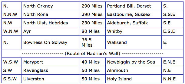
W.
2. Inner Circle - Equidistant from Haltwhistle to
-
Meriden - Traditional Centre Of England,
-
Cambo - Centre of Wales
-
Pomeroy - Centre of Northern Ireland
-
The Forest of Atholl - Centre of Scotland
3. Outer Circle - Equidistant from Haltwhistle to the extremities of the British Isles
-
Jersey
-
Scilly Isles
-
Fastnet
-
Bantry Bay
-
Shetland